A PREVIOUSLY unseen Queensland Government plan to build a road bridge linking the Redlands mainland to North Stradbroke Island (Minjerribah) has emerged, revealing just how close the controversial project once came to proceeding.
The proposal, outlined in a series of official letters and briefing papers dated February 1985, shows that then National Party State Government had identified a preferred bridge route and was actively engaging with major construction firm John Holland to advance the project.
The material was discovered among personal papers while a reader was managing a family move into aged care in the Redland Bay area and was subsequently provided to the newspaper for review.
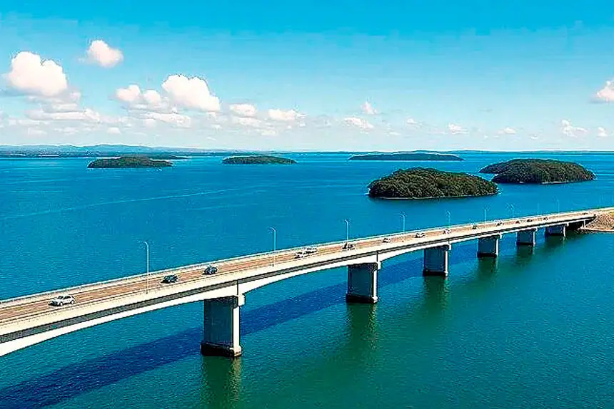
It details a continuous road and bridge connection from the Redlands mainland to North Stradbroke Island via Pannikin and Russell islands – a project that would have fundamentally reshaped the region.

The plan is outlined in formal correspondence from the Co-ordinator-General of the Premier’s Department, Sir Syd Schubert, to John Holland, one of Australia’s largest infrastructure builders at the time.
Sir Syd, who died in 2015, was a close confidant of then premier Joh Bjelke-Petersen.
In a letter dated February 14, 1985, Sir Syd advised that the Queensland Government had already determined its preferred route for the bridge: from the mainland at Redland Bay, across Pannikin Island, through Russell Island and then over the Canaipa Channel to North Stradbroke Island.
A follow-up letter on February 27 enclosed detailed plans, maps and a comprehensive briefing paper, inviting John Holland to submit an amended proposal.
The tone of the correspondence suggests the project was well beyond the conceptual stage.
Sir Syd wrote that much of John Holland’s earlier submission details “remain valid” and that any new proposal need only outline specific amendments.
He also foreshadowed presentations to an inter-departmental committee once a submission was received.
The technical scope was extensive.
The proposal included three major bridges, each with a minimum width of 12 metres, designed to carry three traffic lanes initially, and ultimately support a four-lane highway.
Navigation clearances were set at up to 25m over the Canaipa Channel, with dedicated navigation spans of 60m to accommodate marine traffic.
On the mainland, the project required significant road upgrades, including a new four-lane deviation near Victoria Point, bridges over Eprapah Creek and Bunker Rd, and widening of Cleveland-Redland Bay Rd.
A toll plaza was proposed near the mainland bridge abutment, indicating the project was expected to be at least partly privately funded.
Costings included in the government briefing paper provide a rare insight into the financial scale of the proposal.
Proponents were required to contribute $10 million in 1984 dollars (approximately $31.2 million today) towards upgrading the mainland regional road network, including $5 million for a Capalaba bypass and $5 million to widen Redland Bay Rd east of Panorama Drive.
Further staged contributions were mandated as traffic volumes increased, including $5.2 million between 1989 and 1994 to upgrade Beenleigh-Redland Bay Road to California Creek, $6.3 million between 1995 and 2000 to extend the upgrades to the Pacific Highway, and a further $2.8 million between 2001 and 2006 to complete the four-lane works on the Redland Bay bypass.
On Russell Island, the Government estimated a minimum of $400,000 for land resumptions alone, with Redland Shire Council advising that infrastructure costs over the first 10 years after bridge completion would be substantial.
These included $5 million for water reticulation, $2.7 million per year for sewerage works over a decade, and a further $3 million per year for roads, drainage, parks and public buildings.
North Stradbroke Island would also have required major investment.
Proponents were expected to fund water supply, sewage treatment, local roads, drainage, recreational facilities and sites for state infrastructure.
The existing mining road, owned by Consolidated Rutile Ltd, would have needed full reconstruction, while allowing uninterrupted mining operations.
A second report outlines State Government-commissioned research into the acquisition of commercial properties in Queensland’s premium tourist centres, along with other land purchases zoned for tourist facilities or special features.
The analysis appears designed to benchmark average acquisition prices, providing developers with guidance on the likely costs associated with land required for the proposed bridge development and related tourist infrastructure on the islands.
Notably, the accompanying letter from Sir Syd Schubert states that development proposals “which do not involve any Government financial assistance to the project will be given preference.”
The project, once costed at $81 million, was eventually deemed “a bridge too far” for the Government and taxpayers.
The plan was officially scrapped by the Queensland Cabinet in February 1986.
Within two years of the correspondence, the Fitzgerald Inquiry had exposed widespread corruption in Queensland’s political system, leading to the fall of the Bjelke-Petersen government and a dramatic shift away from large-scale development-driven infrastructure proposals.
The documents offer a striking glimpse of an alternative history – one in which Russell Island, North Stradbroke Island and the mainland were connected by road, opened to mass development, and irrevocably changed.